Description
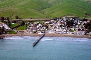 Cayucos Creek – Whale Rock Area
The Cayucos Creek – Whale Rock Area Watershed lies within the southern portion of the California Coast Range. The watershed is bounded to the west by Pacific Ocean and the east by the Santa Lucia Mountain Range. Consistent with the CalWater HUC 10 grouping scale, the watershed area contains four major drainages that independently reach the Pacific Ocean: Cayucos Creek, Old Creek, Toro Creek and Morro Creek, the latter of which borders and shares some attributes with the Morro Bay watershed. The headwaters of the watershed are in Santa Lucia Range, reaching a maximum elevation of approximately 2,345 feet with the lowest elevation at around at sea level, draining in to the Pacific Ocean. Whale Rock reservoir is located in the watershed approximately ½ mile east of the community of Cayucos. The dominant land use in the watershed is Agriculture with the sea side town of Cayucos providing an urban core area with tourist oriented opportunities.
WATERSHED OVERVIEW
|
Hydrologic Unit Name:
|
Estero Bay 10
|
|
Water Planning Area:
|
Cayucos WPA 3
|
|
Acreage:
|
54,974 acres
|
|
Flow to:
|
Pacific Ocean / Estero Bay
|
|
Groundwater Basin(s):
|
Cayucos Valley, Old Valey, Toro Valley and Morro Valley
|
|
Jurisdictions:
|
County of San Luis Obispo, Cayucos, Morro Bay (ptn) Los Padres National Forest
|
|
Watershed Plans:
|
None
|
Full Data Snapshot
Download the Watershed Snapshot for more detailed information such as:
- Rainfall
- Geology
- Hydrology models
- Vegetation
- Special status wildlife and plants
- Land use
- Demographics
- Major changes in the watershed
- Watershed health
- Groundwater