Description
 Huer Huero Creek Watershed
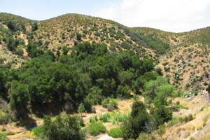
The Huer Huero watershed is located in the eastern portion of San Luis Obispo’s North County region. The Huer Huero creek is an ephemeral underground stream which flows to directly to the Salinas River. The headwaters occur in the Coast Ranges, south of Creston and reach elevations of approximately 3312 feet. The confluence of the Huer Huero with the Salinas River occurs in Paso Robles. The dominant land use in the watershed is agriculture, with vineyards comprising a large percentage. The watershed is divided into two main drainages, the Upper Huer Huero and the Lower Huer Huero. Highway 41 East bisects the watershed. A portion of the Los Padres National Forest is located in the southeast portion of the watershed and contains the highest elevations in the watershed.
WATERSHED OVERVIEW
|
Hydrologic Unit Name:
|
Salinas 9
|
|
Water Planning Area:
|
Salinas/Estrella WPA 14
|
|
Acreage:
|
103,496 acres
|
|
Flow to:
|
Salinas River – to Pacific Ocean (Monterey Bay National Marine Sanctuary)
|
|
Groundwater Basin(s):
|
Paso Robles
|
|
Jurisdictions:
|
County of San Luis Obispo, Creston (ptn), City of Paso Robles (ptn.), Los Padres National Forest
|
|
Watershed Plans:
|
None
|
Full Data Snapshot
Download the Watershed Snapshot for more detailed information such as:
- Rainfall
- Geology
- Hydrology models
- Vegetation
- Special status wildlife and plants
- Land use
- Demographics
- Major changes in the watershed
- Watershed health
- Groundwater