Description
 Upper Salinas – Santa Margarita Area Watershed
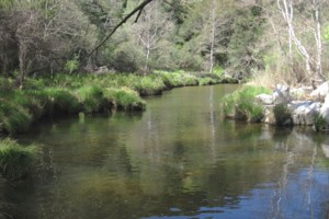
The Upper Salinas- Santa Margarita Area Watershed is located in northern San Luis Obispo County and includes a portion of the Salinas River and adjacent tributaries. The drainage rises to a maximum elevation of approximately 2,800 feet above mean sea level with steep topography categorizing much of the western portion of the watershed. The watershed contains two major drainages; Atascadero Creek and Parole Canyon. The watershed contains a mix of urban and rural residential land uses as well as agricultural land uses. A portion of the Los Padres National Forest is also contained within the watershed along the western boundary. The City of Atascadero is located at the northern end of the watershed boundary and the community of Santa Margarita is located within the central and southern portions of the watershed. Other land uses include two quarries, Atascadero Lake, and a wastewater treatment plant. Water supply for the watershed area is dominated by wells, including those used by the Atascadero Mutual Water Company to supply urban residents and commercial uses.
WATERSHED OVERVIEW
|
Hydrologic Unit Name:
|
Salinas 9
|
|
Water Planning Area:
|
Santa Margarita WPA 12, Atascadero/Templeton WPA 13
|
|
Acreage:
|
82,156 acres
|
|
Flow to:
|
Salinas River to Pacific Ocean (Monterey Bay National Marine Sanctuary)
|
|
Groundwater Basin(s):
|
Paso Robles, Atascadero sub-Basin, Rinconada Valley
|
|
Jurisdictions:
|
County of San Luis Obispo, City of Atascadero, Town of Santa Margarita, Los Padres National Forest
|
|
Watershed Plans:
|
Salinas River Watershed Action Plan
|
Full Data Snapshot
Download the Watershed Snapshot for more detailed information such as:
- Rainfall
- Geology
- Hydrology models
- Vegetation
- Special status wildlife and plants
- Land use
- Demographics
- Major changes in the watershed
- Watershed health
- Groundwater