Description
 Huasna River Watershed
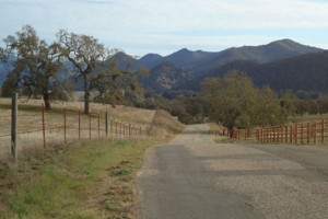
The Huasna River Watershed is an inland basin located in southern San Luis Obispo County. The drainage rises to a maximum elevation of approximately 3,000 feet above sea level. Huasna River flows to the Cuyama River at the downstream end of the Huasna River watershed above Twitchell Dam, which is in the Cuyama River Watershed downstream. Huasna River watershed has a number of tributary basins with their headwaters in the Santa Lucia and La Panza Mountain Ranges: Huasna Creek, Carrie Creek, Haystack Creek and Arroyo Seco Creek. Agriculture is the principal land use in the area, ranging from small irrigated farms to large cattle ranches. A substantial portion of the area consists of hilly and mountainous land with chaparral and oak woodlands, suitable only for limited grazing. Other land uses includes oil exploration and recreation onthe Los Padres National Forest.
WATERSHED OVERVIEW
|
Hydrologic Unit Name:
|
Santa Maria HU 12
|
|
Water Planning Area:
|
Huasna Valley WPA 8
|
|
Acreage:
|
75,122 acres
|
|
Flow to:
|
Cuyama River at Twitchell Reservoir
|
|
Groundwater Basin(s):
|
Huasna Valley
|
|
Jurisdictions:
|
County of San Luis Obispo; Los Padres National Forest
|
|
Watershed Plans:
|
None
|
Full Data Snapshot
Download the Watershed Snapshot for more detailed information such as:
- Rainfall
- Geology
- Hydrology models
- Vegetation
- Special status wildlife and plants
- Land use
- Demographics
- Major changes in the watershed
- Watershed health
- Groundwater