Arroyo Grande Groundwater Basin
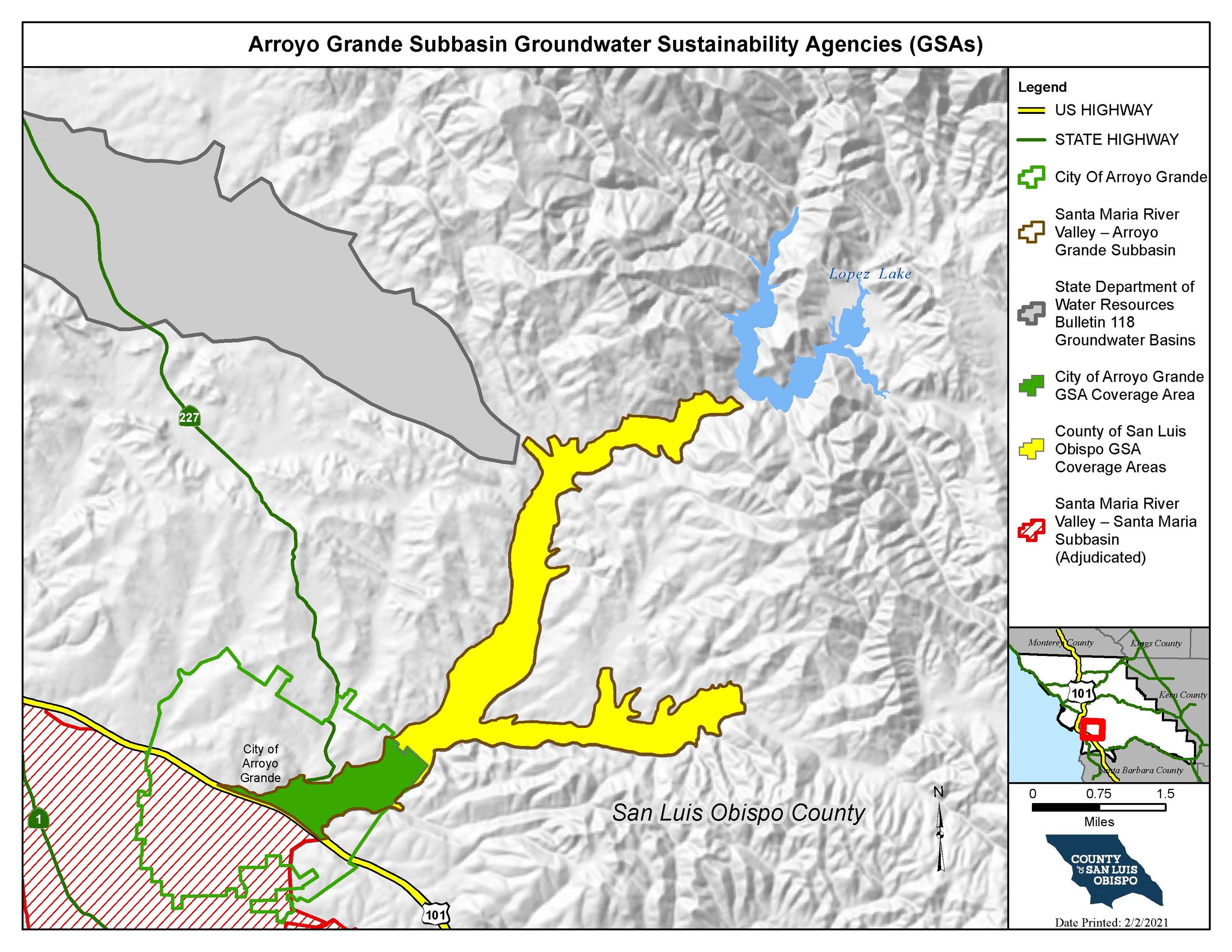
Due to the final results of DWR’s groundwater basin boundary modifications in 2019, the Santa Maria River Valley – Arroyo Grande (No. 3-12.02) Subbasin (AG Subbasin) and Santa Maria River Valley – Santa Maria (No. 3-12.01) Subbasin (Santa Maria Subbasin) were established as separate subbasins within the previous Santa Maria River Valley Basin (No. 3-12). The Arroyo Grande Subbasin is approximately seven miles long, oriented in a northeast-southwest direction, extending from Lopez Dam to the adjudicated area boundary (approximately coincident with the Wilmar Avenue Fault and Highway 101). The tributary valley of Tar Springs Creek is about three miles long, oriented east-west, and joins Arroyo Grande Creek about three miles upstream of Highway 101. Land surface of Arroyo Grande Creek valley extends from an altitude of about 380 feet Above Mean Sea Level (AMSL) at the base of Lopez Dam to about 100 ft AMSL at the bottom of the valley. Tar Springs Creek Valley extends from an altitude of about 360 ft AMSL to 160 ft AMSL at the confluence with Arroyo Grande Creek. Mountain ridges on the north side of the valley rise steeply to elevations of over 1500 feet AMSL near Lopez Dam.
SGMA and the Arroyo Grande Subbasin
Prior to DWR’s creation of the AG Subbasin, both the County of San Luis Obispo and the City of Arroyo Grande formed Groundwater Sustainability Agencies (GSAs) within their respective service areas to fully cover the AG Subbasin. Subsequently, the Arroyo Grande Subbasin was designated as a very low priority basin. Therefore, it is currently not subject to SGMA requirements. However, the County received state grant funding to develop a GSP in compliance with the Sustainable Groundwater Management Act (SGMA). The County of San Luis Obispo GSA and the City of Arroyo Grande GSA jointly developed a Groundwater Sustainability Plan (GSP) for the sustainable management of the Arroyo Grande Subbasin. The technical analysis resulting from the GSP will provide information necessary for the preparation of the Arroyo Grande Creek Habitat Conservation Plan under development by the San Luis Obispo County Flood Control and Water Conservation District as well as a better overall understanding of the hydrogeologic processes (i.e., surface water and groundwater interconnections) in the Arroyo Grande Creek Watershed, both of which would assist with effective management of the District’s Zone 3.
Click here to view the Final Arroyo Grande Subbasin GSP
Draft GSP documents and workshop materials can be accessed via the GSP Resources folder.
Interactive Map of the Arroyo Grande Subbasin
Welcome to the SGMA Interactive Data Viewer for the Arroyo Grande Subbasin! This is an interactive mapping system to help you to navigate around the Arroyo Grande Subbasin by panning, zooming, or searching for a specific parcel or street address that you would like to locate. There are different map layers that can be shown and superimposed in this interactive mapping system such as boundaries of groundwater basins, cities, roads, SGMA eligible entities, and others by checking the layer names indicated on the left panel layer menu. To search and locate a specific APN or street address on the map:
- Enter either the nine-digit parcel number (APN) including hyphens or the complete street address in the “Search...” bar on the upper right hand corner of the map screen and then click on the search button to locate it. The APN or street address that you just entered will appear on the left panel and a location marker will show up on the map to identify the location.
- Click on the APN or street address name shown on the left panel layer menu will zoom in to the specified location for a close-up look