Santa Maria River Valley Groundwater Basin
The Santa Maria River Valley Groundwater Basin (Santa Maria Basin), DWR Bulletin 118 Basin No. 3-12 , underlies the coastal portion of the northern Santa Barbara and southern San Luis Obispo Counties. The DWR-defined Santa Maria Basin encompasses approximately 184,000 acres (288 square miles), of which approximately 61,220 acres (95.7 square miles) are within San Luis Obispo County. Annual precipitation for the basin ranges from 13 to 17 inches with an average of 15 inches. Groundwater is found in alluvium, dune sands, and the Orcutt, Paso Robles, Pismo, and Careaga Formations of the basin. Groundwater is unconfined throughout most of the basin except in the coastal portion where it is confined.
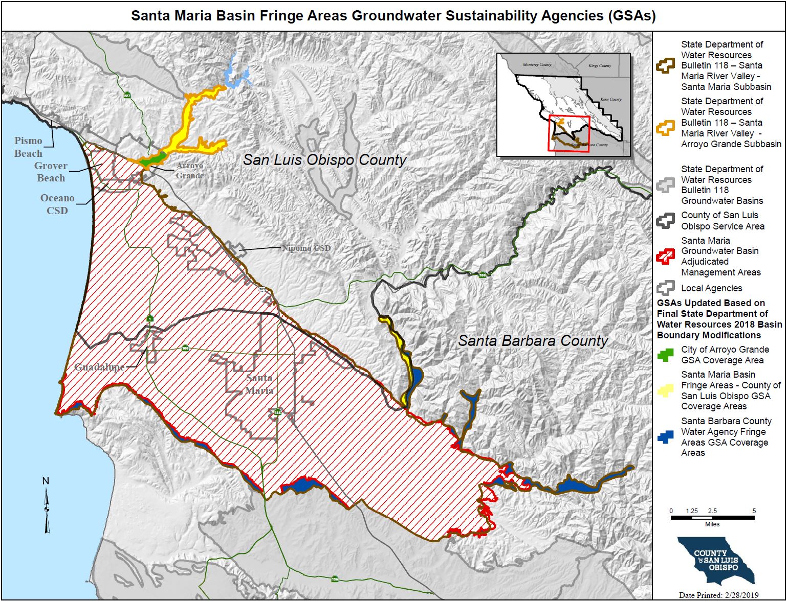
HistoryIn 2015, the State legislature approved an important new groundwater management law known as the Sustainable Groundwater Management Act (SGMA). DWR designated Santa Maria Basin as a high priority basin. SGMA requires that high and medium priority basins comply with the new law, with certain exceptions for certain adjudicated basins such as the Santa Maria Basin. SGMA does not apply to the portion of the Santa Maria Basin that is at issue in the litigation (“adjudicated area”) provided that certain requirements are met. The adjudicated areas cover a majority of the basin, and are managed by the Northern Cities Management Area, Nipomo Mesa Management Area, and the Santa Maria Valley Management Area. For the fringe areas, which are the non-adjudicated areas outside the adjudicated portion of the basin, the County of San Luis Obispo, the City of Arroyo, and the County of Santa Barbara formed groundwater sustainability agencies to manage the basin areas within their respective jurisdictions. The non-adjudicated basin fringe areas must comply with SGMA requirements. As a result of DWR’s decisions on the final 2018 basin boundary modification processes in February 2019, three of the Santa Maria Basin fringe areas were removed from the basin and the Arroyo Grande Creek fringe area was established as a subbasin (see “Final Basin Boundary Modifications Release” in Recent News Section below for more details). The map below displays both the adjudicated areas exempt from SGMA, and the newly modified basin boundaries, which shows the remaining fringe areas that are subject to SGMA. For information specific to the Arroyo Grande Subbasin, please click here.
| ||
Recent News & Announcements
| ||
Meeting Calendar - Agendas and Minutes | ||
How do I get involved?
| ||
Interactive Map of Santa Maria River Valley Groundwater BasinWelcome to the SGMA Interactive Data Viewer for the Santa Maria Groundwater Basin! This is an interactive mapping system to help you to navigate around the Santa Maria Groundwater Basin by panning, zooming, or searching for a specific parcel or street address that you would like to locate. There are different map layers that can be shown and superimposed in this interactive mapping system such as boundaries of groundwater basins, cities, roads, SGMA eligible entities, and others by checking the layer names indicated on the left panel layer menu. To search and locate a specific APN or street address on the map:
| ||
Sign up for the SGMA Mailing ListClick here to subscribe to the SGMA email notification list! |