Newsletter Issue #1 - November 2026
Author: Public Works, Water Resources Division
Date: 11/16/2026 3:47 PM
The November 2026 Water Resources Update features the DESAL Plan Feasibility Study, Adelaida Area Hydrogeologic Study, two new stream gages, Arroyo Grande Creek winter storm preparation, and updates from the Water Resources Advisory Committee and Flood Control Zones 1/1A and 9.
DESAL Plan Feasibility Study Complete
Could ocean desalination become part of San Luis Obispo County’s future water-supply portfolio? The San Luis Obispo County Flood Control and Water Conservation District recently completed an important step toward answering that question.
Working with local water agencies and other partners, the District completed a U.S. Bureau of Reclamation Title XVI Feasibility Study (Study) evaluating potential ocean desalination concepts along the county’s coastline. The study narrowed a broader range of possibilities to five project concept alternatives in the Cambria, Cayucos/Estero Marine Terminal, Morro Bay, South SLO County Wastewater Treatment Plant, and Nipomo Mesa areas.
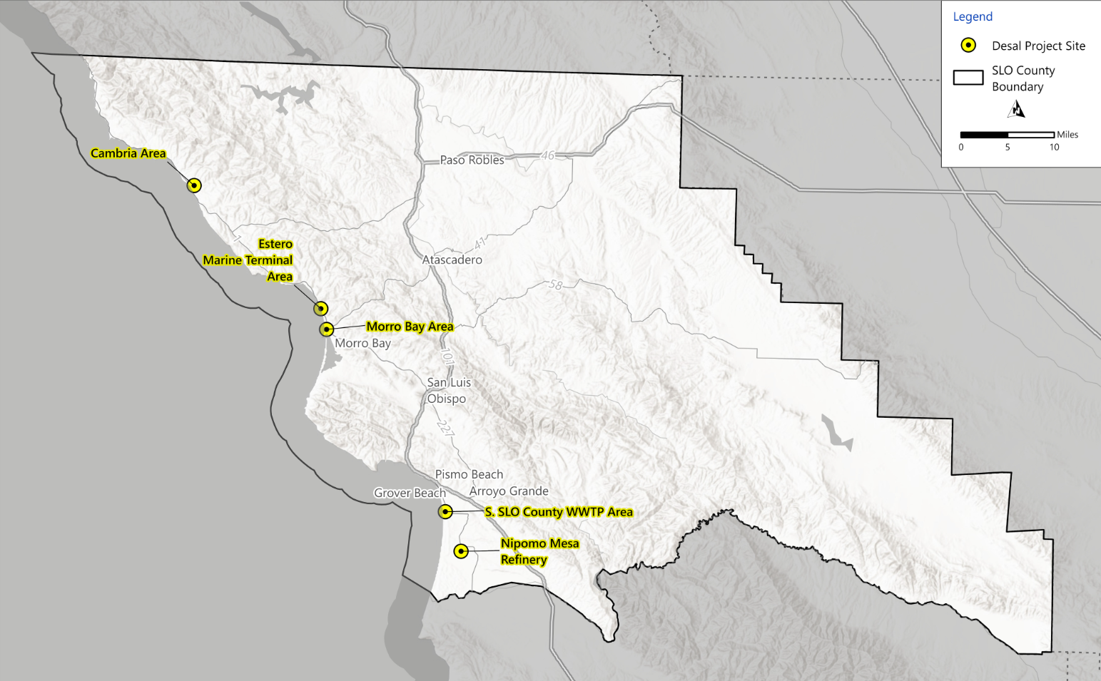
Five Project Conept Alternatives evaluated as part of the DESAL Plan Feasibility Study
The Study found each of the five project concept alternatives feasible at a planning level, meaning they are considered viable and permittable based on the information available today. The Study concludes with this short-list of alternatives for futher consideration, it does not select or approve a preferred desalination project. Instead, it provides participating agencies with information about potential water-supply benefits, infrastructure needs, environmental and permitting considerations, costs, and opportunities for regional partnerships.
Community Input Along the Way
The District gathered public input through the DESAL Plan comment portal, virtual and in-person community meetings, online surveys, Water Resources Advisory Committee updates, a public review period for the draft study, etc. Feedback focused on water-supply needs, affordability, environmental and permitting considerations, project locations, and the role desalination could play in the region’s future water-supply portfolio.
Where does the DESAL Plan Stand?
The USBR Title XVI Feasibility Study was presented to the Board of Supervisors on September 1, 2026, marking completion of Phase 2a of the overall 5-Phase DESAL Plan. The Board received and filed the study and directed staff to continue regional discussions with potential project partners about water supply, resiliency, and the desalination concepts identified through the Study.
There is currently no desalination project selected to move forward for planning or construction. Moving into Phase 2b would depend on interest from participating agencies and would require new funding and agreements. Phase 2b would consist of more detailed site analysis, engineering, environmental review, financial planning, permitting, and continued public engagement.
Desalination remains one of several strategies being explored to improve long-term regional water-supply reliability, alongside conservation, recycled water, storage, transfers, and optimization of existing water systems.
Learn more: visit the DESAL Plan Project website or contact Angela Ford, Project Engineer at [email protected].
Understanding Groundwater in the Adelaida Area
What does groundwater look like beneath the hills west of Paso Robles in the fractured rock under Adelaida?
The San Luis Obispo County Flood Control and Water Conservation District is working with the U.S. Geological Survey (USGS) and on a multi-year Adelaida area hydrogeologic study. Although the area is not a State-designated groundwater basin, many residents and agricultural users rely on groundwater stored and moving through the area’s complex fractured-rock system.
The goal of the study is to better understand local groundwater conditions, availability, and long-term sustainability to inform potential future water management decisions.
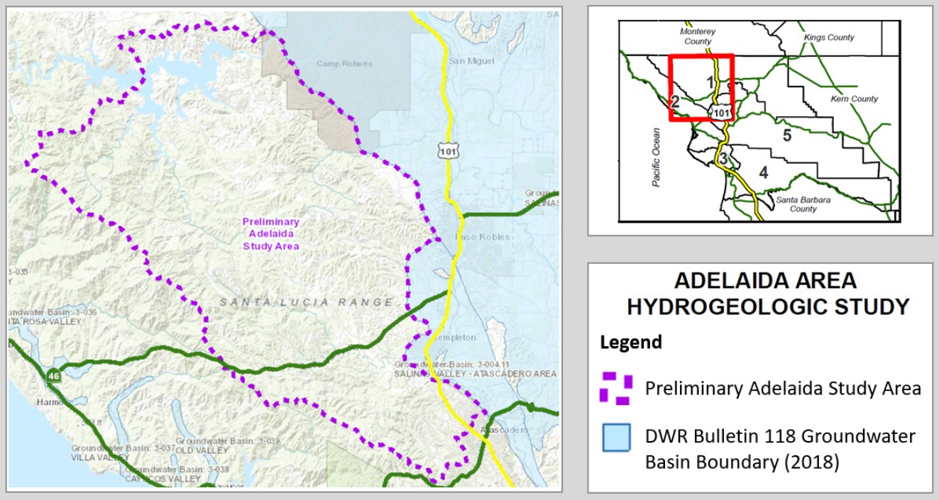
Map of the Adelaida Study area and nearby State-designated groundwater basins
Project Status
The initial data compilation and hydrologic field-data collection tasks are complete. Between 2022 and 2024, USGS collected groundwater-level measurements from more than 60 wells, monitored streamflow, and gathered water-quality information from wells, streams, springs, and other sites.
USGS is now analyzing that information to better understand groundwater and surface-water interactions, identify areas of groundwater recharge and discharge, estimate water-budget components, and assess the impacts of changes in land-use and climate. Interpretive reports and supporting data releases are also in development.
The study is expected to conclude in 2027 with publication of a comprehensive USGS report and presentation of the findings. Data collected through the project are already publicly available through USGS Water Data for the Nation and the project’s interactive map.
Learn more: visit the Adelaida Study Project website or contact Angela Ford, Project Engineer at [email protected].
Two New Stream Gages Added to the County Network
The San Luis Obispo County Flood Control and Water Conservation District owns and operates a network of rain, stream, and reservoir gages across the county. These stations collect hydrologic data that support flood preparedness and response, water-resource planning, and public access to information about local conditions.
With grant funding from the California Department of Water Resources’ Stream Gage Improvement Program (CalSIP), the District recently completed construction on two new stream gages that expand monitoring in the Arroyo Grande Creek and San Luis Obispo Creek watersheds.
Tar Springs at Huasna Creek
Construction has been completed on a new stream gage at the County bridge on Huasna Road at Tar Springs Creek, a major tributary to Arroyo Grande Creek. The station will provide publicly available streamflow information and improve the data available to support water-management decisions in the watershed.
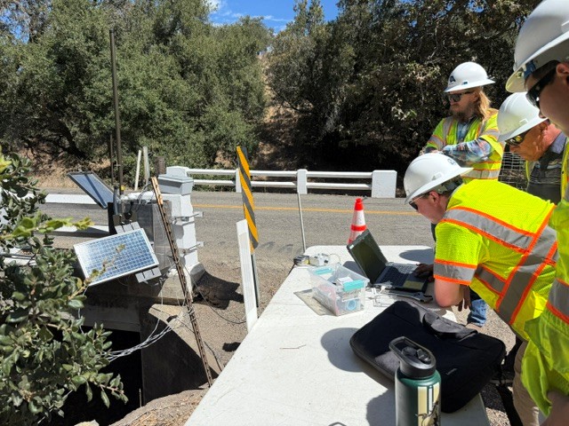
SLO County Public Works staff installing and testing the new Tar Springs Creek Stream Gage at Huasna Road. Photo: SLO County Public Works
San Luis Obispo Creek Near Avila Beach
Construction has also been completed on a new stream gage on San Luis Obispo Creek at San Luis Bay Drive, approximately three-quarters of a mile northeast of Avila Beach. The station will expand monitoring in the lower San Luis Obispo Creek watershed as part of Flood Control Zone 9 and provide additional information to support flood awareness, water-resource planning, and a better understanding of changing stream conditions.
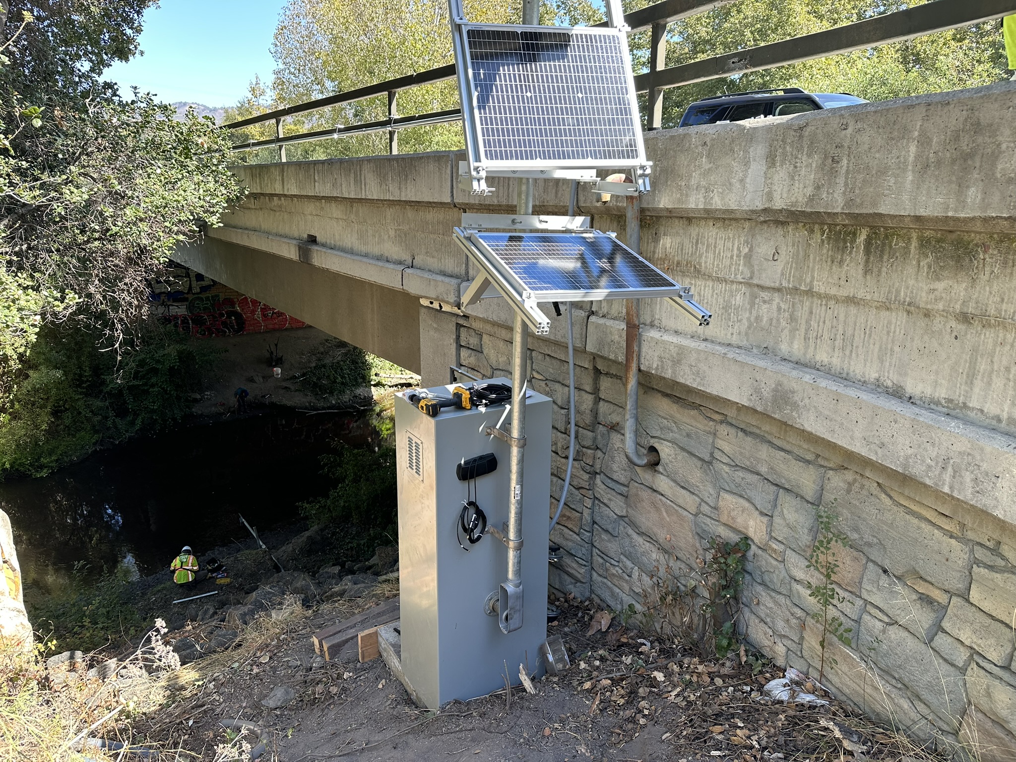
New San Luis Obispo Creek Stream Gage at San Luis Bay Drive. Photo: SLO County Public Works.
Together, the two new gages help fill important monitoring gaps and strengthen the District’s ability to track conditions across the county.
Explore the network: visit wr.slocountywater.org to view the County’s real-time rain, stream, and reservoir monitoring data from gages throughout San Luis Obispo County. Questions? Contact the Cathy Martin, Project Engineer at [email protected].
Preparing Arroyo Grande Creek for the 2026-27 Winter Storm Season
Before winter storms arrive, the San Luis Obispo County Flood Control and Water Conservation District works throughout the Arroyo Grande Creek Channel to maintain flood capacity and prepare for potential high-water events. This area, known as Flood Control Zone 1/1A, includes the Arroyo Grande and Los Berros Creek channels and associated levee system serving portions of Arroyo Grande and Oceano.
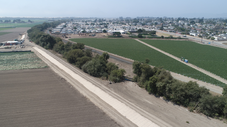
View west along Arroyo Grand Creek and the surrounding agricultural area near Oceano.
Photo: SLO County Public Works
This year’s work has included vegetation management using hand crews and goat grazing, removal of broken and dead hazardous trees that could obstruct the channel, and ongoing woody-debris management and in-channel inspections. Culverts and flap gates are also inspected, cleaned, and maintained before storm season and checked throughout the winter, while routine levee inspections help identify repairs that may be needed before storms.
Recent Flood Protection Projects
The District has also completed several major improvements following the 2022–23 winter storms. Approximately 11,500 cubic yards of sediment and storm debris were removed from the channel in 2023 to restore conveyance capacity.
Levee rehabilitation completed in 2024 added erosion protection and four underground hydraulic barrier walls to reduce the potential for seepage damage. Additional work completed in 2025 extended turf reinforcement along the south levee, strengthened the previous breach area with rock protection, and removed sediment near the Union Pacific Railroad bridge to improve flow through the area.
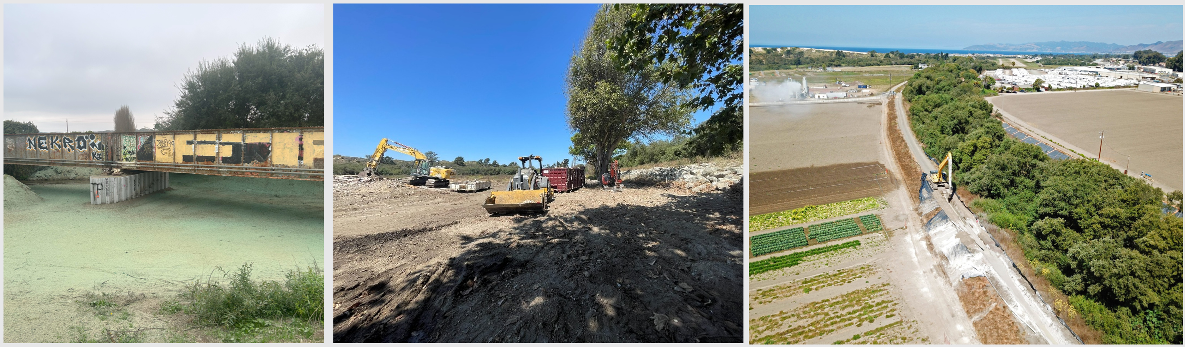
Flood-protection improvements along Arroyo Grande Creek completed following the 2022-23 winter storms. Photo: SLO County Public Works
In addition to channel maintenance, District staff are preparing for the upcoming storm season by updating the Levee Operations Emergency Response Plan, completing preventative maintenance on rain and stream gages used for storm-response notifications and emergency triggers, and maintaining emergency-response contractor agreements.
Be Ready Before the Rain
Residents near the Arroyo Grande Creek levee are encouraged to know their evacuation zone, monitor rainfall and stream conditions, and prepare before storms arrive. Stay informed: Visit ReadySLO.org to sign up for emergency notifications and find information about preparing for storms and other emergencies.
Countywide Winter Storm Preparation
Each year, Public Works also prepares roads, drainage systems, flood-control facilities, equipment, and response resources across the county to prepare for winter storms. On October 20, 2026, Public Works participated in a joint department presentation to the Board of Supervisors outlining countywide winter storm preparedness and emergency-response readiness. View the meeting materials and recorded presentation on the Board of Supervisors website.
Learn more: visit https://www.slocounty.ca.gov/zone1-1a for additional information or contact Melissa Pasa, Project Engineer at [email protected].
Advisory Committee Updates
Water Resources Advisory Committee (WRAC)
The WRAC advises the Board of Supervisors on water-resource policy, programs, and funding for the San Luis Obispo County Flood Control and Water Conservation District.
At the October 7 WRAC meeting, Water Resources and Office of Emergency Services staff provided an update on preparations for the 2026–27 winter storm season, including flood preparedness, emergency response coordination, and seasonal readiness. The committee also received updates on rainfall and reservoir conditions, groundwater management, Flood Control Zones 1/1A and 9, the Master Water Report, the State Water Project, and the DESAL Plan.
Next WRAC Meeting
December 2, 2026 | 1:30 p.m.
SLO City/County Library Community Room, 995 Palm Street, San Luis Obispo, CA
https://www.slocounty.ca.gov/wrac
Zone 1/1A Advisory Committee
The Flood Control Zone 1/1A Advisory Committee provides recommendations to the San Luis Obispo County Flood Control and Water Conservation District on actions to provide flood protection for properties within Flood Control Zones 1 and 1A.
At the September 15 Zone 1/1A meeting, Water Resources staff and project consultants provided updates on the Arroyo Grande Creek Levees Flood Study, including development of the hydraulic model and the approach for evaluating potential flood-reduction alternatives and nature-based solutions. The committee also received updates on the Waterway Management Program, long-term funding study, Meadow Creek Lagoon Habitat Restoration Project, community outreach, and preparations for the upcoming winter storm season.
Next Zone 1/1A Meeting
December 8, 2026 | 3:00 p.m.
Sheriff’s South Patrol Station, 1681 Front Street, Oceano, CA
https://www.slocounty.ca.gov/zone1-1
Zone 9 Advisory Committee
The Zone 9 Advisory Committee provides recommendations on flood-control and watershed issues affecting San Luis Obispo Creek and its tributaries.
At the October 14 Zone 9 meeting, Water Resources staff presented on preparations for the upcoming winter storm season. District and City of San Luis Obispo staff also provided updates on the Waterway Management Plan, including vegetation management, hydraulic model updates, and stream gages. The committee also discussed a draft letter to the Board of Supervisors and received ongoing updates on creek maintenance and Arundo removal.
Next Zone 9 Meeting
December 9, 2026 | 1:30 p.m.
SLO Veterans Memorial Building, 801 Grand Avenue, San Luis Obispo, CA
https://www.slocounty.ca.gov/zone9