Description
 Black Sulphur Spring Watershed
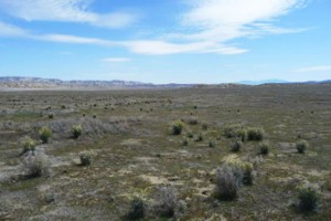
The Black Sulphur Spring Watershed lies in the eastern portion of San Luis Obispo‘s North County region and includes the southern portion of the Carrizo National Monument. The total watershed area is approximately 143,160 acres with a majority of the acreage located within San Luis Obispo County (137,489 acres). The remaining acreage is located within Kern County to the East. The watershed is bounded by Temblor Range to the east, Caliente Range and San Juan Hills to the west and drains entirely into Soda Lake. The Black Sulphur Watershed contains two major drainages: the Caliente Range and Elkhorn Plain. The highest elevation in the watershed is about 3,411 feet and the lowest elevation is approximately 1,919 feet. Elkhorn Plain is in this watershed, draining toward the basin floor. The watershed is transected by San Andreas Fault. The groundwater basin underlying the watershed, the Carrizo Plain basin, is recharged from percolation of stream flow and infiltration of precipitation. Users of the basin include a small public water system serving local school, agricultural and residential purposes, and solar farms. The dominant land use is rangeland.
WATERSHED OVERVIEW
|
Hydrologic Unit Name:
|
Carrizo Plain 11
|
|
Water Planning Area:
|
Carrizo Plain WPA 10
|
|
Acreage:
|
143,160 acres total / 137,489 acres within San Luis Obispo County
|
|
Flow to:
|
Soda Lake
|
|
Groundwater Basin(s):
|
Carrizo Plain
|
|
Jurisdictions:
|
County of San Luis Obispo, Bureau of Land Management
|
|
Watershed Plans:
|
None
|
Full Data Snapshot
Download the Watershed Snapshot for more detailed information such as:
- Rainfall
- Geology
- Hydrology models
- Vegetation
- Special status wildlife and plants
- Land use
- Demographics
- Major changes in the watershed
- Watershed health
- Groundwater