Description
 Alamo Creek Watershed
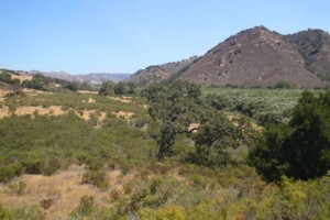
The Alamo Creek Watershed is an inland basin located in southern San Luis Obispo County. The drainage rises to a maximum elevation of approximately 3,800 feet above sea level. Alamo Creek flows to the Cuyama River at Twitchell Reservoir. Twitchell dam is downstream in the Cuyama Watershed, but its presence affects habitats, hydrology, and land use in Alamo Creek Watershed. Major tributary basins with their headwaters in the La Panza Mountain Range: Little Jollo, Sheep, Kennel, Los Machos, and Branch Creeks. The watershed is dominated by the Los Padres National Forest which permits recreation including camping, hunting, and off-highway vehicle uses. The watershed also has agricultural land uses.
WATERSHED OVERVIEW
|
Hydrologic Unit Name:
|
Santa Maria HU 12
|
|
Water Planning Area:
|
Huasna Valley WPA 8
|
|
Acreage:
|
56,277 acres
|
|
Flow to:
|
Cuyama River at Twitchell Reservoir
|
|
Groundwater Basin(s):
|
None
|
|
Jurisdictions:
|
County of San Luis Obispo, U. S. Forest Service
|
|
Watershed Plans:
|
None
|
Full Data Snapshot
Download the Watershed Snapshot for more detailed information such as:
- Rainfall
- Geology
- Hydrology models
- Vegetation
- Special status wildlife and plants
- Land use
- Demographics
- Major changes in the watershed
- Watershed health
- Groundwater