Description
 Arroyo Grande Creek Watershed
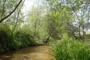
The Arroyo Grande Creek Watershed is a coastal basin located in southern San Luis Obispo County. The drainage rises to a maximum elevation of approximately 3,100 feet above sea level. The watershed includes the tributaries of Tally Ho (Corbett), Tar Springs and Los Berros Creeks. Meadow Creek is a remnant marsh drainage system that enters Arroyo Grande Creek, just upstream of the confluence with the ocean. Arroyo Grande Creek empties into an estuary adjacent to the Oceano lagoon. The watershed is dominated by agricultural land uses including vineyards, ranches and row crops. The urban core of the City of Arroyo Grande is at the confluence of Tally Ho Creek with Arroyo Grande Creek. Other land uses include Lake Lopez Reservoir and a regional airport in Oceano.
WATERSHED OVERVIEW
|
Hydrologic Unit Name:
|
Estero Bay HU 10
|
|
Water Planning Area:
|
South Coast WPA 7
|
|
Acreage:
|
95,998 acres
|
|
Flow to:
|
Pacific Ocean
|
|
Groundwater Basin(s):
|
Santa Maria River Valley; Arroyo Grande Creek sub-basin; Edna Valley
|
|
Jurisdictions:
|
County of San Luis Obispo, City of Arroyo Grande, City of Grover Beach, Community of Oceano, Los Padres National Forest, Pismo State Beach
|
|
Watershed Plans:
|
Arroyo Grande Creek Watershed Management Plan (CCSE, 2009)
|
Full Data Snapshot
Download the Watershed Snapshot for more detailed information such as:
- Rainfall
- Geology
- Hydrology models
- Vegetation
- Special status wildlife and plants
- Land use
- Demographics
- Major changes in the watershed
- Watershed health
- Groundwater