Description
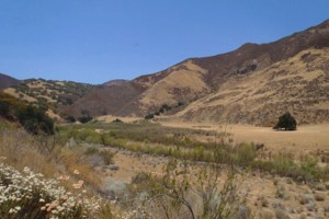 Cuyama River Watershed
The Cuyama River Watershed starts in Ventura County. The river generally flows northward, and then in a westerly direction to a point of confluence with the Sisquoc River near the town of Garey where it joins the Santa Maria River. The San Luis Obispo County line approximately follows the Cuyama River. A portion of the northern tributaries and part of the Cuyama River are within the southwestern part of San Luis Obispo County. The northern tributaries rise to a maximum elevation of almost 4,950 feet above sea level at Caliente Mountain with their headwaters in the La Panza and Caliente Mountain Ranges. Twitchell Reservoir is near the downstream end of the Cuyama River Watershed, formed behind Twitchell Dam. The watershed is dominated by rural and agricultural land uses including ranches, orchards, vineyards and row crops. Other land uses include oil and gas production, Los Padres National Forest and Bureau of Land Management lands.
WATERSHED OVERVIEW
|
Hydrologic Unit Name:
|
Santa Maria HU 12
|
|
Water Planning Area:
|
Cuyama Valley WPA 9 Huasna Valley WPA 8
|
|
Acreage:
|
729,600 acres total / 140,408 acres within San Luis Obispo County
|
|
Flow to:
|
Santa Maria River
|
|
Groundwater Basin(s):
|
Cuyama Valley, Santa Maria Valley
|
|
Jurisdictions:
|
County of San Luis Obispo Los Padres National Forest
|
|
Watershed Plans:
|
None
|
Full Data Snapshot
Download the Watershed Snapshot for more detailed information such as:
- Rainfall
- Geology
- Hydrology models
- Vegetation
- Special status wildlife and plants
- Land use
- Demographics
- Major changes in the watershed
- Watershed health
- Groundwater